1.Rani Ka Bav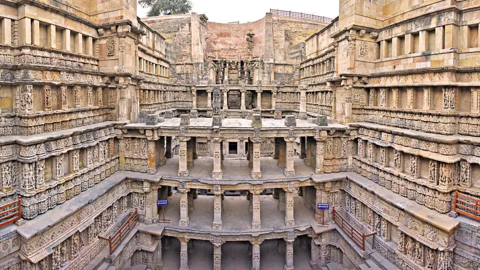
The only real sign of Patan’s former glory is this astoundingly beautiful step-well. Located on the banks of the Saraswati River, this is one of the oldest and finest stepwells in Gujarat and is remarkably preserved. Steps lead down through multiple levels with lines of carved pillars and more than 800 sculptures, mostly on Vishnu-avatar themes, as well as striking geometric patterns. The stepwell is made in the form of an inverted temple. It showcases superior craftsmanship of the era, and the unique Maru-Gurjara architectural style and houses sculptures similar to the Vimalavasahi temple in Mount Abu and Sun temple at Modhera.
History
The stepwell was built in 1063 by Rani Udayamati of the Chaulukya Dynasty to commemorate her husband, Bhimdev I. A 1304 composition of Jain monk, Merutunga, mentions that Udayamati, the daughter of Naravaraha Khangara, built this stepwell at Patan. The same composition also mentions that the stepwell was commissioned in 1063 and was completed after 20 years. Archeologists Henry Cousens and James Burgess visited it in 1890s when it was completely buried under silt and only the shaft and few pillars were visible. The stepwell was rediscovered in 1940s, and the Archeological Survey of India restored it in 1980s. The stepwell has been listed as one of UNESCO’s World Heritage Sites since 2014.
Facts
1.It is known as the queen stepwell
2.It was a unique form of water storage system
3.Architecture style of the stepwell
4.There are art work of all gods and goddesses
5.It was built on the theme of incarnations of Lord Vishnu
6.It is the place for Hindu Ritual
7.It is believed it had medicinal properties
Importance
Rani ki Vav is the only stepwell in the world that has been included in the World Heritage List. It is also a proof of how excellent the system of water management was in ancient India. These vavs are the most developed and comprehensive example of 11th century Indian underground architectural structure and techniques of using groundwater resources in water management.
Best Time To Visit
Between October to March
2.Dholavira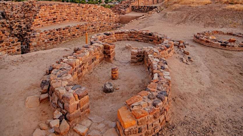
Dholavira is an archaeological site at Khadirbet in Bhachau Taluka of Kutch District, in the state of Gujarat in western India, which has taken its name from a modern-day village 1 kilometre (0.62 mi) south of it. This village is 165 km (103 mi) from Radhanpur. Also known locally as Kotada timba, the site contains ruins of a city of the ancient Indus Valley civilization. Earthquakes have repeatedly affected Dholavira, including a particularly severe one around 2600 BC.
Dholavira’s location is on the Tropic of Cancer. It is one of the five largest Harappan sites and the most prominent of archaeological sites in India belonging to the Indus Valley Civilization.It is also considered as having been the grandest of cities of its time. It is located on Khadir bet island in the Kutch Desert Wildlife Sanctuary in the Great Rann of Kutch. The 47 ha (120 acres) quadrangular city lay between two seasonal streams, the Mansar in the north and Manhar in the south.The site was thought to be occupied from c.2650 BCE, declining slowly after about 2100 BCE, and to have been briefly abandoned then reoccupied until c.1450 BCE; however, recent research suggests the beginning of occupation around 3500 BCE (pre-Harappan) and continuity until around 1800 BCE (early part of Late Harappan period).
The site was initially discovered by a resident of Dholavira village, Shambhudan Gadhvi, in early 1960s who made efforts to bring government attention to the location. The site was “officially” discovered in 1967-68 by J. P. Joshi, of the Archaeological Survey of India (ASI), and is the fifth largest of eight major Harappan sites. It has been under excavation since 1990 by the ASI, which opined that “Dholavira has indeed added new dimensions to personality of Indus Valley Civilisation. The other major Harappan sites discovered so far are Harappa, Mohenjo-daro, Ganeriwala, Rakhigarhi, Kalibangan, Rupnagar and Lothal.
It was named as a UNESCO World Heritage Site under the name Dholavira: a Harappan City on 27 July 2021
Architecture and material culture
Estimated to be older than the port-city of Lothal the city of Dholavira has a rectangular shape and organization, and is spread over 22 ha (54 acres). The area measures 771.1 m (2,530 ft) in length, and 616.85 m (2,023.8 ft) in width. Unlike Harappa and Mohenjo-daro, the city was constructed to a pre-existing geometrical plan consisting of three divisions – the citadel, the middle town, and the lower town. The acropolis and the middle town had been furnished with their own defence-work, gateways, built-up areas, street system, wells, and large open spaces. The acropolis is the most thoroughly fortified[12] and complex area in the city, of which it appropriates the major portion of the southwestern zone. The towering “castle” stands is defended by double ramparts.[ Next to this stands a place called the ‘bailey’ where important officials lived.[ The city within the general fortifications accounts for 48 ha (120 acres). There are extensive structure-bearing areas which are outside yet integral to the fortified settlement. Beyond the walls, another settlement has been found. The most striking feature of the city is that all of its buildings, at least in their present state of preservation, are built of stone, whereas most other Harappan sites, including Harappa itself and Mohenjo-daro, are almost exclusively built of brick. Dholavira is flanked by two storm water channels; the Mansar in the north, and the Manhar in the south. In the town square, there is a area high above the ground, called the “Citadel”.
.
Importance
Dholavira, the archaeological site of a Harappan-era city, received the UNESCO world heritage site tag on Tuesday. While Dholavira became the fourth site from Gujarat and 40th from India to make the list, it is the first site of the ancient Indus Valley Civilisation (IVC) in India to get the tag
Best Time To Visit
Winter season is the ideal season for a visit to Dholavira. The months when Dholavira is ideal for a trip is for the months of October – March. Monsoon is also a good time to visit, while summer season, with unbearably hot climate, is the least advisable time for a visit.
3.Vijay Vilas Palace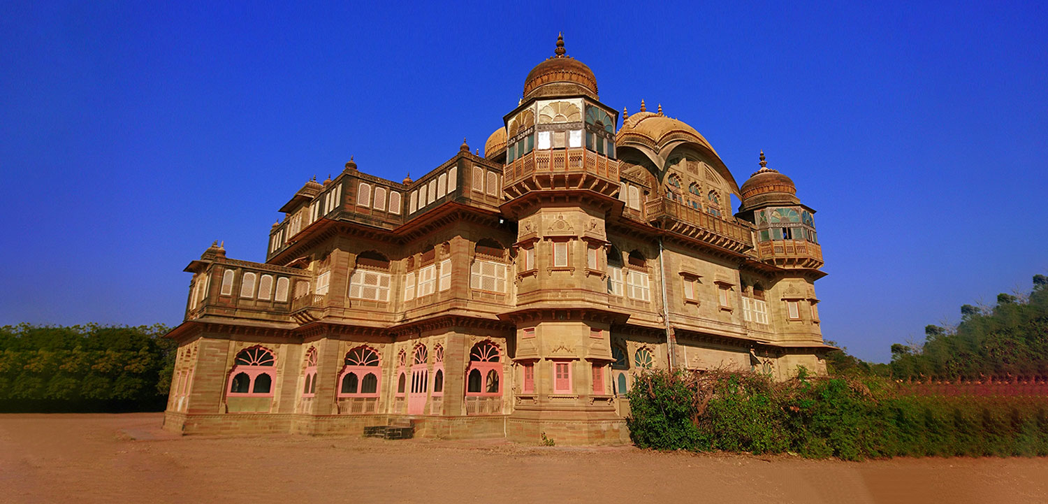
This weathered 1920s palace lies 7 km west of Mandvi, amid extensive orchards along a private beach. Originally a summer abode for the Kutch rulers, its first floor is now the main residence of the elderly Maharajah of Bhuj. The view from the roof is impressive and the rooms, with their stuffed wildlife and faded grand furniture, are worth a peek. The sandstone structure has extensive jali work, coloured glass, domed bastions and murals and the influence of the Kutch community of artisans and their unique style is evident.
History
The palace was built in the reign of Maharao Shri Khengarji III, who was the Maharao of Kutch. It was meant to be a summer resort for his son and heir to the kingdom, Yuvraj Shri Vijayaraji. The palace is named ‘Vijaya Vilas Palace’ after him. The construction of palace started in year in 1920 and completed in 1929. Shri Vijayaraji died in 1948. A chhatri (decorative tombstone) in his memory stands on the premises of the palace.
Facts
1.The whole palace is built using red sandstone.
2.The architecture and plan of the palace is largely based on the palaces of Orchha and Datia.
3.The current royal family of the Kutch state resides in this palace, and they made this summer resort their permanent residence after parts of Ranjit Vilas got damaged due to the Bhuj earthquake in 2001.
4.The palace is named after Yuvraj Shri Vijayaraj Ji as it was built for him
Importance
It was meant to be a summer resort for his son and heir to the kingdom, Yuvraj Shri Vijayaraji. The palace is named ‘Vijaya Vilas Palace’ after him. The construction of palace started in year in 1920 and completed in 1929
Best Time To Visit
The Vijay Vilas Palace is open to tourists from 9 AM to 1 PM & 3PM to 6PM. The beach resorts and accommodations are open throughout the day though. The ticket price for visiting the palace is just Rupees 10 and with an additional charge of Rupees 50 for photography.
4.Gir National Park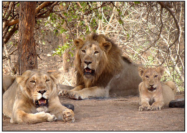
Gir National Park and Wildlife Sanctuary, also known as Sasan Gir, is a forest, national park, and wildlife sanctuary near Talala Gir in Gujarat, India. It is located 43 km (27 mi) north-east of Somnath, 65 km (40 mi) south-east of Junagadh and 60 km (37 mi) south-west of Amreli. It was established in 1965 in the erstwhile Nawab of Junagarh’s private hunting area, with a total area of 1,412 km2 (545 sq mi), of which 258 km2 (100 sq mi) is fully protected as a national park and 1,153 km2 (445 sq mi) as wildlife sanctuary.[1] It is part of the Khathiar-Gir dry deciduous forests ecoregion.
The 14th Asiatic Lion Census 2015 was conducted in May 2015. In 2015, the population was 523 (27% up compared to previous census in 2010). The population was 411 in 2010 and 359 in 2005. The lion population in Junagadh District was 268 individuals, 44 in Gir Somnath District, 174 in Amreli District, and 37 in Bhavangar District. There are 109 males, 201 females and 213 cubs.
Gir National Park is closed from 16 June to 15 October every year, throughout the monsoon season.
History
In the 19th century, the rulers of Indian princely states used to invite the British colonists for hunting expeditions. At the end of the 19th century, only about a dozen Asiatic lions were left in India, all of them in the Gir Forest, which was part of the Nawab of Junagarh’s private hunting grounds. British viceroys brought the drastic decline of the lion population in Gir to the attention of the Nawab of Junagadh, who established the sanctuary. Today, it is the only area in Asia where Asiatic lions occur and is considered one of the most important protected areas in Asia because of its biodiversity. The Gir ecosystem with its diverse flora and fauna is protected as a result of the efforts of the government forest department, wildlife activists and NGOs. It is now considered the jewel of Gujarat’s ecological resources.
Wildlife
The count of 2,375 distinct fauna species of Gir includes about 38 species of mammals, around 300 species of birds, 37 species of reptiles and more than 2,000 species of insects.
The carnivores group mainly comprises the Asiatic lion, Indian leopard, jungle cat, striped hyena, golden jackal, Bengal fox,Indian gray mongoose and ruddy mongoose, and honey badger. Asiatic wildcat and rusty-spotted cat occur, but are rarely seen.
The main herbivores of Gir are chital, nilgai, sambar, four-horned antelope, chinkara and wild boar. Blackbucks from the surrounding area are sometimes seen in the sanctuary. Among the smaller mammals, porcupine and hare are common, but the pangolin is rare.
The reptiles are represented by the mugger crocodile, Indian cobra, tortoise and monitor lizard which inhabit the sanctuary’s bodies of water. Snakes are found in the bush and forest. Pythons are sighted at times along the stream banks. Gir has been used by the Gujarat State Forest Department which formed the Indian Crocodile Conservation Project in 1977 and released close to 1000 marsh crocodiles into Lake Kamaleshwar and other small bodies of water in and around Gir.[citation needed]
The plentiful avifauna population has more than 300 species of birds, most of which are resident. The scavenger group of birds has 6 recorded species of vultures. Some of the typical species of Gir include crested serpent eagle, endangered Bonelli’s eagle, changeable hawk-eagle, brown fish owl, Indian eagle-owl, rock bush-quail, Indian peafowl, brown-capped pygmy woodpecker, black-headed oriole, crested treeswift and Indian pitta. The Indian grey hornbill was not found from the last census of 2001.
Facts
1.Gir National Park is the last abode for the surviving population of the Asiatic Lions in the world.
2.Sasan Gir Provides Shelter to around 2,375 different wildlife species including Asiatic Lions.
3.Gir Wildlife Sanctuary is located in the vicinity of charming Lake Nalsarovar which is a very popular sanctuary.
4.Asiatic Lions and African Lions both are subspecies of the same species.
5.Asiatic Lions split from African lions perhaps 1000,000 years ago.
6.Important to note that lions are only social cats that live in groups called pride.
7.Asiatic lions once prowled from the Middle East to India. Now, only a fraction of these magnificent animals survives in the wild.
Importance
The Gir National Park and Wildlife Sanctuary are one of the most significant national parks in India that provides shelter to the Asiatic Lions. Apart from the lions, it also possesses innumerable species of various plants and animals.
Best Time To Visit
As the protected area remains closed from June to October, the best time to visit Gir is in winter, from November to March. The summer months of April and May are very hot but ideal for wildlife photography and wildlife viewing.
5.Lothal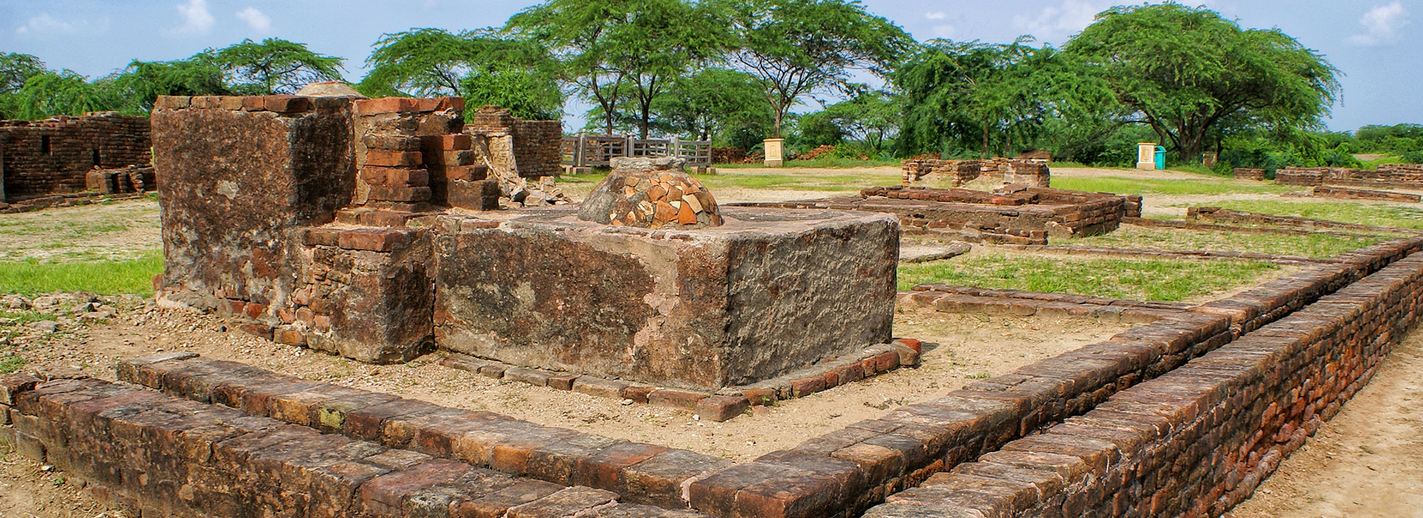
About 80km southwest of Ahmedabad, the city that stood at this archaeological site 4500 years ago was one of the most important of the Indus Valley civilisation, which extended into what is now Pakistan. Excavations have revealed the world’s oldest known artificial dock, which was connected to an old course of the Sabarmati River. Other features include the acropolis, the lower town, the bead factory, the warehouses, and the drainage system. The site has been nominated to be enlisted as a UNESCO World Heritage Site. The traveller can see fascinating finds by archeologists like canals and dockyards that explain how this was an important trading city. Artefacts suggest that trade may have been conducted with Mesopotamia, Egypt and Persia. An entire township with market and dock has been unearthed here. An Archaeological Museum (10am–5pm, Friday closed) near the site houses a number of artefacts like jewellery, pottery, seals, religious symbols, and objects of daily use here.
History
It is said that Lothal is a combination of two words; Loth and thal, which in Gujarati means ‘the mound of the dead.’ The city was inhabited during 3700 BCE and was a thriving trading port. The excavation started from 13 February 1955 to 19 May 1960 by the Archaeological Survey of India (ASI) to unearth the ancient city. Archaeologists believe that the city was a part of a major river system on the ancient trade route from Sindh to Saurashtra in Gujarat. Excavations here have offered the greatest number of antiquities in the archaeology of modern India.
Importance
Lothal was one of the most significant locations during the Indus Valley Era. It was one of the most important and thriving trade centres in ancient times. The world’s oldest known artificial dock, which was connected to an old course of the Sabarmati River was found during an excavation in Lothal.
Best Time To Visit
July to March
6.Uparkot Fort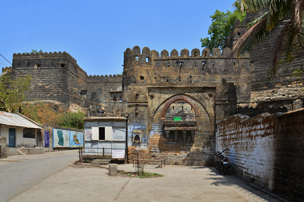
This ancient fort is believed to have been built in 319 BC by the Mauryan emperor Chandragupta, though it has been extended many times. In places, the ramparts reach 20m high. It’s been besieged 16 times, and legend has it that the fort once withstood a 12-year siege. The views over the city and east to Girnar Hill are superb, and within its walls, there is a magnificent former mosque, a set of millennia-old Buddhist caves and two fine step-wells. The fort has two fine step-wells both cut from solid rock. The circular, 41m-deep Adi Kadi Vav was cut in the 15th century and named after two slave girls who used to fetch water from it. Navghan Kuvo, 52m deep and designed to help withstand sieges, is almost 1000 years old and its magnificent staircase spirals around the well shaft. Look for the centuries-old dovecotes.
History
A fort and town was established at the foothills of Girnar hill during reign of the Maurya Empire and continued to be used during Gupta period, but it lost its importance when the capital of Saurashtra region was moved from Junagadh to Vallabhi by Maitraka. Chudasamas settled around Junagadh from 875 CE according to bards when they acquired Vamansthali (Vanthli) from Chavda ruler.
A 10th-century Chudasama king Graharipu (r. c.940-c.982)[6][7][8] cleared the old citadel free from the jungle. From the evidence contained in the Hemchandra’s Dvyashraya, it can be concluded that Graharipu laid the foundations of the citadel as it now exists. the legend is told about its rediscovery.
Legends
After several Chudasamas of Vamansthali had ruled, a woodcutter one day managed to cut his way through the forest and came to a place where stone walls and a gate existed. Nearby sat a holy man in contemplation, and on being asked by the woodcutter the name of the place and its history, he replied that its name was “Juna” — old. The woodcutter returned by the way he had come to Vamansthali, and reported his discovery to the Chudasama ruler, who ordered the forest to be cleared away. This being done, the fort came into sight. But there was none who knew its history, or who could tell more than the holy man had told the woodcutter. So the place became known as “Junagadh” for want of a better title.
If this story is to be believed, either Graharipu rediscovered an ancient stronghold or else after he had built the fort, it was abandoned and afterwards found again by a later ruler Navaghana who transferred Chudasama capital from Vamansthali to Junagadh.
Architecture
The Uparkot is one of the most interesting of old forts. The parapets on the east, where the place is commanded by higher ground, have been raised at least three times to give cover against the increasingly long range of projectiles.
The entrance is beyond the town in the east wall, and consists of three gateways, one inside the other. The fort walls are from 60 to 70 feet high, forming a massive cluster of buildings. The inner gateway, a beautiful specimen of the Torana, has been topped by more later Indo-Islamic work.
On the rampart above the gate is an inscription of Mandalika III, dated 1450. Near this is the Jumma Masjid built by Mahmud Begada.
The Tomb of Nuri Shah, close to the mosque, is ornamented with fluted cupolas, and a most peculiar carving over the door. There are two Wells in the Uparkot — the Adi Kadi Vav, said to have been built in ancient times by the maids of the Chudasama rulers, is descended by a long flight of steps; and the Navghan Kuvo, cut to a great depth in the soft rock, and with a circular staircase.
Uparkot Caves are 2nd-3rd century Buddhist caves located in the Uparkot. It is double storyed cave complex used by Buddhist monks during ancient times.
Nawabi Lake is a square artificial lake located in the Uparkot.
Importance
The oldest part of Junagadh, and the center of any visit to the city, is the upper citadel, known as Uparkot. The fort was built by Chandragupta of the Mauryan empire around 320 BC, and archaeological evidence confirms this, showing that Uparkot had been inhabited continuously since the 3rd century BC.
Best Time To Visit
October to March
7.dwarkadhish Temple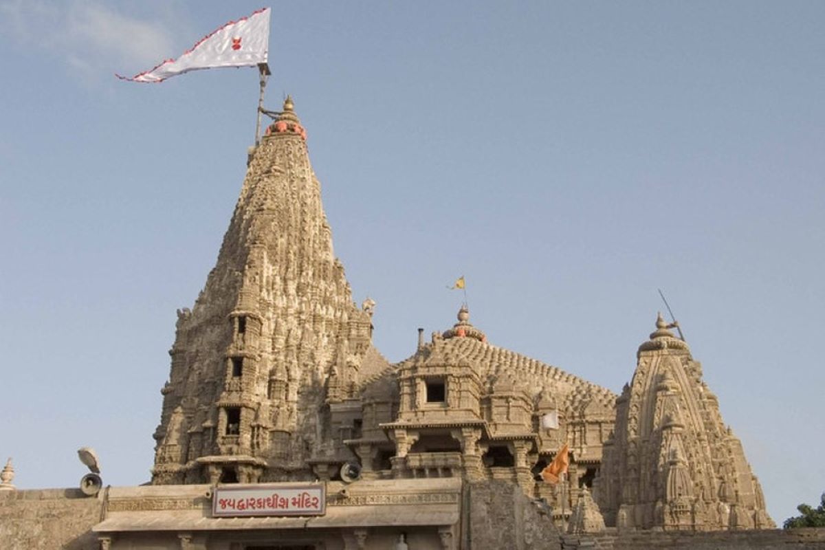
Situated at the cusp of Gomti River and the Arabian Sea in Gujarat is the majestic Dwarkadhish Temple. An important Hindu pilgrimage site for Vaishnavites, especially the devotees of Lord Krishna, Dwarkadhish Temple is one of the Char Dham. The temple is also a key religious tourism site in the country, and is of architectural as well as religious importance. Dwarkadhish Temple, also known as Jagat Mandir (universal shrine) or Trilok Sundar (the most beautiful in all three worlds), is a site protected by the Archaeological Survey of India. Seeming to rise from the Arabian Sea, it is the main temple situated in the Dwarka city of Gujarat’s Devbhoomi Dwarka district.
History
The town of Dwarka in Gujarat has a history that dates back centuries, and mentioned in the Mahabharat epic as the Dwaraka Kingdom. Situated on the banks of river Gomti, the town is described in legend as the capital of Krishna. Evidence such as a stone block with script, the way the stones were dressed showing that dowels had been used, and an examination of anchors found on the site suggest that the harbour site dates only to historical times, with some of the underwater structure being late Medieval. Coastal erosion was probably the cause of the destruction of what was an ancient port.
Hindus believe that the original temple was constructed by Vajranabh, the great grand son of Krishna, over the residential palace of Krishna. It was destroyed by Sultan Mahmud Begada in 1472.
The current temple in Chaulukya style was constructed in 15-16th century. The temple covers area of 27-metre by 21-metre with east–west length of 29-metre and north–south width of 23 metres. The tallest peak of the temple is 51.8 m high
Legend
As per Hindu legend, Dwarka was built on a piece of land by Krishna that was reclaimed from the sea. Sage Durvasa once visited Krishna and his wife Rukmini. The sage wished that the pair took him to their palace. The pair readily agreed and started walking with the sage to their palace. After some distance, Rukmini got tired and she requested some water from Krishna. Krishna dug a mythical hole that brought in river Ganga to the place. Sage Durvasa was furious and cursed Rukmini to remain in the place. The temple where Rukmini’s shrine is found, is believed to the place where she stood.
Structure
It is a five storied edifice built over 72 pillars (sandstone temple with 60 pillars is also mentioned).There are two important entrances to the temple, one is the main entry door which is called the Moksha Dwar (meaning “Door to Salvation”) and the exit door which is known as the Swarga Dwar (meaning: “Gate to Heaven”).
The main deity deified in the sanctum is of Dwarkadeesh, which is known as Trivikrama form of Vishnu and is depicted with four arms. On the chamber to the left of the main altar is the deity of Balarama, elder brother of Krishna. The chamber to the right houses the images of Pradyumna and Aniruddha, son and grandson of Krishna. In several shrines surrounding the central shrine there are idols of goddess Radha, Jambavati, Satyabhama and Lakshmi. Shrines of Madhav Raoji (another name for Krishna), Balrama and sage Durvasa is also present in the temple.There are also two separate shrines dedicated to Radha Krishna and Devaki just in front of the central shrine of Dwarkadhish.
The temple spire rises to a height of 78 metres (256 ft) and a very large flag with symbols of Sun and Moon is hoisted on it. The flag, triangular in shape, is of 50 feet (15 m) length. This flag is changed four times a day with a new one and Hindus pay a huge sum of money to hoist it by purchasing a new flag. The money received on this account is credited to the trust fund of the temple to meet the operation and maintenance expenses of the temple.
Facts
1.Janamashtmi Celebration
2.Structure of Dwarkadhish Temple
3.Flag at the top of Temple
4.Priceless sculptures of Dynasties
5.Entrance to Temple
6.Gomti River 56 steps away
7.Dwarka land reclaimed from sea
8.Rukmani Temple
9.Gopi Lake or ‘Gopi Talav’
10,Ancient City
Importance
It is one of the Sapta Puri, the seven holy cities of India. The temple is also the location of Dvaraka Pitha, one of the four peeths (religious centers) established by Adi Shankaracharya (686-717) who pioneered unification of Hindu religious beliefs in the country.
Best Time to Visit
November To February
8.Palitana Jain Temple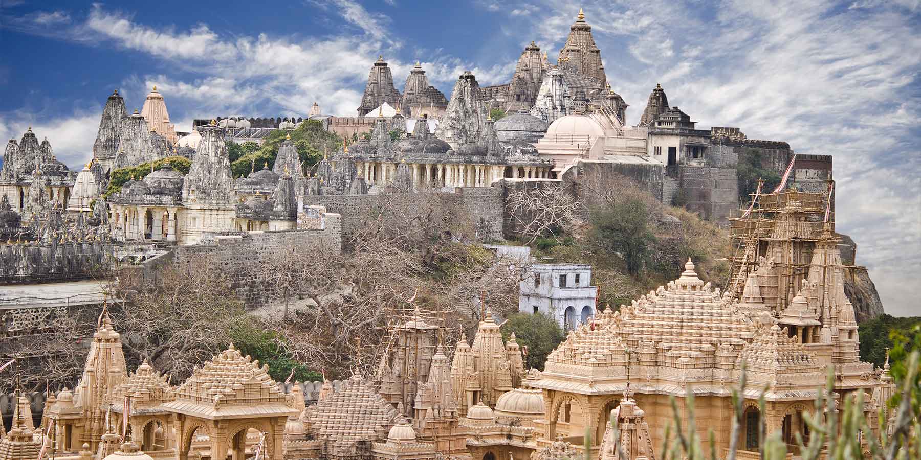
The hustling, dusty town of Palitana, 51 km southwest of Bhavnagar, has grown rapidly to serve the pilgrim trade around the Shatrunjaya Hill. The sacred site contains hundreds of shrines that were sanctified when Rishabha, the first Tirthankara of Jainism, gave his first sermon in the temple on the hilltop. Even though the climb to the temples is a rigorous one, it awards a dazzling sight of the intricately carved temples. During the Kartik Purnima festival, accommodation around town floods with pilgrims and is best booked in advance.
One of Jainism’s holiest pilgrimage sites, Shatrunjaya is an incredible hill studded with temples, built over 900 years. It is said that Adinath (also known as Rishabha), the founder of Jainism, meditated beneath the rayan tree at the summit. The temples are grouped into tunks (enclosures), each with a central temple flanked by minor ones. The summit is situated at an elevation (height) of 7,288 feet (2,221 m). Reaching it involves climbing over 3,750 stone steps. to the temples adds to the extraordinary experience. Most days, hundreds of pilgrims make the climb; crowds swell into the thousands around Kartik Purnima, which marks the end of Chaturmas, a four-month period of spiritual retreat and material self-denial that coincides with the monsoon season. White robed monks walk past you. As you near the top of the hill, the track forks. The main entrance, Ram Pole, is reached by bearing left, though the best views are to the right, where on a clear day you can see the Gulf of Cambay. Inside the Nav Tonk Gate, one path leads left to the shrine of Angar Pir – a Muslim saint who protected the temples from a Mughal attack. To the right, the second tunk you reach is the Chaumukhji Tunk, containing the Chaumukh (Four-Faced Shrine), built in 1618 by a Jain merchant. Images of Adinath, the first Jain tirthankar (believed to have attained enlightenment here), face the four cardinal directions. You can easily spend a couple of hours wandering among the hundreds of temples up here. The biggest and one of the most splendid and important, with a fantastic wealth of detailed carving, is the Adinath Temple, on the highest point on the far (south) side. People who walk down grab a bowl of curd from scores of sellers to restore their energy.
History
In the traditional texts and beliefs, this sacred hill became important to Jainism millions of years ago, since the age of Adinatha (locally called Adishvera). Adinatha himself lived for 8.4 million years, and patronized this Satrunjaya hills site many times in his long life. He is believed to have visited Satrunjaya nearly 700 million times, more than any other Jain site. Thereafter, Satrunjaya has been cherished and patronized by other Tirthankaras of Jainism, including Risabhanatha and his son Bharata. These hills and Palitana host Adinatha’s principal temple.
According to the Shatrunjaya Mahatmya by Dhanesvara, a Jaina text in Sanskrit traceable to about the 14th century CE, Mahavira recited the legends of Rishabha to a solemn assembly on Satrunjaya when deity Indra requested him to do so. After nearly 300 verses, the text begins the description of Bharatam Varsham, followed by the glory of Satrunjaya. The text declares it so holy, that even thinking about it “expiates many sins”. It then gives 108 alternate names for this site in verses 331 to 335, such as Pundarika, Siddikshetram, Mahabala, Surasaila, Vimaladri, Punyarasi, Subhadra, Muktigeham, Mahatirtham, Patalamula, Kailasa, and others.Of these names, the 11th-century Jaina scholar Hemachandra mentions two: Satrunjaya and Vimaladri.
In the Jain belief, the first Tirthankara Rishabha sanctified the hill where he delivered his first sermon. It was his first disciple Pundarika, who attained Nirvana at Shatrunjay, hence the hill was originally known as “Pundarikgiri”. There exists a marble image of Pundaraksvami consecrated in samvat year 1064 (1120 CE) by Shersthi Ammeyaka to commemorate the sallekhana of a muni belonging to the Vidhyadhara Kula.
Bharata Chakravartin, the father of Pundarik and half-brother of Bahubali, is believed in Jain mythistory to have visited Shatrunjaya many times. In some Jain literature, it is claimed to be the site of the first Jaina temple many millions of years ago.
Vividha Tirtha Kalpa, composed by Jinaprabha Suri in the 14th century CE, describes the shrines and legends of Palitana temples.
Architecture
These temples have a unique architectural style. The ornamentation is such that in sunlight their appear to have been made up of ivory. One of the temples, Adishwar is considered to be the holiest one among all. The other temples include Sampriti Raj, Adinath, Kumarpal and Bimal Shah. The images of the deity are made up of marble and are beautified by gold ornaments studded with precious stones.
The Jain temple of the Digambars is one of the ancient temples. It contains nine shrines with a number of idols of the Tirthankaras encrypted on it. The main temple consists of the idol of Bhagwan Shantinath. This idol is 42 inch in height and is made up of pure white marble. In this temple beautiful idols of Bhima, Arjuna and Yudhisthir have also been also installed.
Facts
It is located on Shetrunjaya hills in the city of Palitana in Gujarat. There are altogether 863 Palitana Jain temples made up of marble. The main temple is situated at a height that can be reached by traversing about 3500 steps from the foot hills. The main temple is dedicated to the first Tirthankara, Rishabhanath.
Importance
Palitana is the world’s only mountain that has more than 900 temples. The Palitana temples and whole mountain are considered the most sacred pilgrimage place (tirtha) by the Jain community, and is the world’s largest Temple Complex.
Best Time To Visit
November–February is the best period to visit the temple town.
9.Buddhist Caves of Junagadh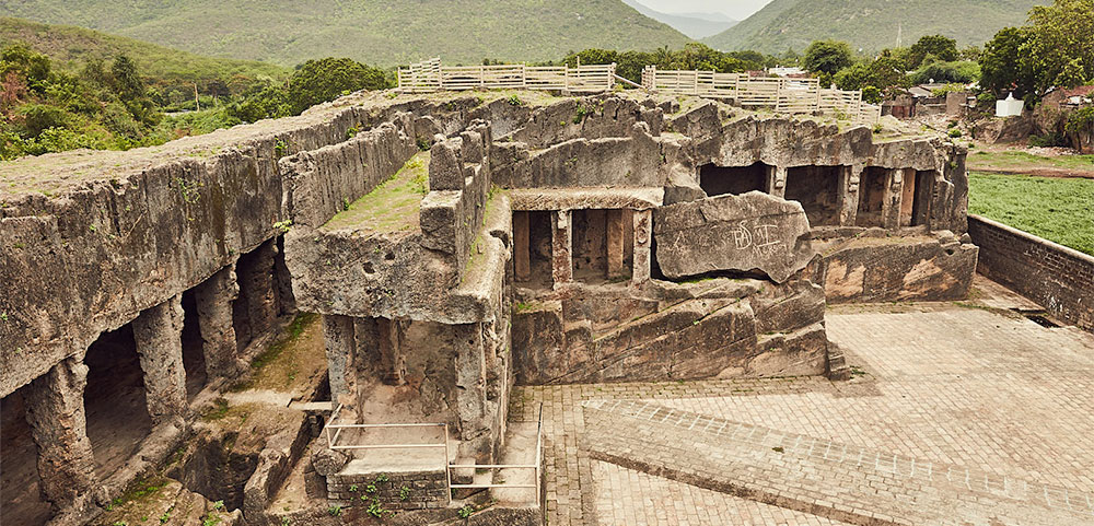
The Buddhist caves of Junagadh are also a reflection of a time, way back in history, lost in stacks of events, for their artistry and monumental structures. Contrary to popular belief as the name suggests, the Junagadh Caves unlike other naturally occurring caves is a complex system of manmade enclosures carved out for the residential purposes of Buddhist monks who chose to lead a celibate life of abstinence. Dating back as far as 1st century AD, a reference time frame for contemporary existence of these caves is during Emperor Asoka’s reign, when foreign spiritual influences were said to be pervading India in essence and display.
Situated in Junagadh, a prominent district in Gujarat, these caves can be reached from the capital Ahmadabad by road or rail and are well connected by transport facilities. The cave complexes are distinctly distinguished by the pattern of their construction. The oldest of the lot and the comparatively plain in terms of relief structures and artistry, is the Khapra Kodiya caves which were largely basic in construction and L shaped with just enough room for seating. They are carved out of living rock and later when they were abandoned monks moved towards the direction of Maharashtra where similar structures were replicated.
The Uparkot caves on the very summit near the Uparkot fort are more spacious with provisions for a courtyard space and display a distinct influence of planned architecture. These are relatively more recent of the lot. The Bava Pyara caves which are slightly older than the Uparkot caves lie outside the Uparkot complex. Constructed after the Khapra Kodiya caves, these caves display intricate interior artwork apparent even today and are sturdier planned and modified versions of their predecessor. The individual enclosures are quite spacious as opposed to cramped spaces in the Khapra Kodiya and have 13 rooms for sighting and visiting at present.
Importance
They were carved into living rock during the reign of Emperor Ashoka and are considered the earliest monastic settlement in the area. After many years of use, they were abandoned because cracks above them allowed water to seep into living quarters, rendering them unusable.
Best Time To Visit
Excluding the searing summers and heavy downpour, each season is considered as appropriate to plan a journey to the Buddhist Caves of Junagadh. A visit made during spring is considered as best. Watch Out! The Buddhist Caves of Junagadh are monuments of national interest.
10.Great Rann Of Kutch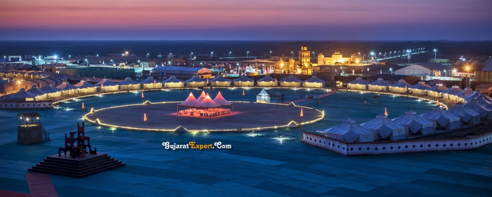
The Little Rann of Kutch, including the Banni grasslands on its southern edge, is situated in the district of Kutch and comprises some 30,000 square kilometres (10,000 sq mi) between the Gulf of Kutch and the mouth of the Indus River in southern Pakistan. The marsh can be accessed from the village of Kharaghoda in Surendranagar District.The Great Rann of Kutch together with the Little Rann of Kutch is called Rann of Kutch.In India’s summer monsoon, the flat semi-desert of salty clay and mudflats, which average 15 meters above sea level, fills with standing water. In very wet years, the wetland extends from the Gulf of Kutch on the west through to the Gulf of Khambhat on the east.The area was a vast shallow of the Arabian Sea until continuing geological uplift closed off the connection with the sea, creating a vast lake that was still navigable during the time of Alexander the Great. The Ghaggar River, which presently empties into the semi-desert of northern Rajasthan, formerly emptied into the Rann of Kutch, but the lower reaches of the river dried up as its upstream tributaries were captured by the Indus and Ganges thousands of years ago. Traces of the delta and its distributary channels on the northern boundary of the Rann of Kutch were documented by the Geological Survey of India in 2000.The Luni River, which originates in Rajasthan, drains into the semi-desert in the northeast corner of the Rann. Other rivers feeding into the marsh include the Rupen from the east and the West Banas River from the northeast. Nara Canal or Puran river which is a delta channel of Indus River empties during floods into Kori Creek located in the Great Rann of Kutch.There are sandy islets of thorny scrub, forming a wildlife sanctuaryand a breeding ground for some of the largest flocks of greater and lesser flamingos. Wildlife, including the Indian wild ass, shelter on islands of higher ground, called bets, during the flooding.
In India the northern boundary of the Greater Rann of Kutch forms the International Border between India and Pakistan, it is heavily patrolled by India’s Border Security Force (BSF) and the Indian Army conducts exercises here to acclimatize its troops to this harsh terrain.This inhospitable salty lowland, rich in natural gas, was one scene of perennial border disputes between India and Pakistan that, in April 1965, contributed to the Indo-Pakistani War of 1965. Later the same year, Prime Minister of the United Kingdom Harold Wilson persuaded the combatants to end hostilities and establish a tribunal to resolve the dispute. A verdict was reached in 1968 which saw Pakistan getting 10% of its claim of 9,100 square kilometres (3,500 sq mi). 90% was awarded to India, although India claimed 100% of the region. Tensions spurted again in 1999 during the Atlantique incident.Elements of dispute remain in Sir Creek, since 1969, there have been twelve rounds of talks between the two nations, without a breakthrough. The twelfth round was completed in June 2012.
The Government of Gujarat hosts an annual 3-month long Rann Utsav festival from December to February every year near Dhordo village in this 500 km2 pristine white salt desert landscapes during winter where tourists can see the various sights of the Rann. Rann Utsav can be visited by anyone but Tent City with 400 tents allows entry only to those who are staying there. Rann Utsav has cultural programs such as the BSF Camel show held at 5 pm, adventure activities like hot-air ballooning, many stalls selling trinkets, handicrafts, food, etc. as well as camel cart excursion, paramotoring, golf carts, ATV rides, yoga and meditation. During the festival 3 to 4-day events are also held at many other exotic locations around the larger Kutch area to expose tourists to the native culture and food, for example, semi-arid grasslands of the Banni reserve exhibits folk architecture, arts and crafts of the area, and folk dance and dance music events are held at several locations with a bonfire under the moon.
Rann Utsav gives visitors not only a chance to experience a full moon on salt deserts but also get a taste of the local culture, cuisine, and hospitality. Specially built local houses are also used to house tourists to give them a taste of local traditions Many adventure clubs and travel clubs organize expeditions.
Facts
1.If you’re right on the trip to Kutch’s extreme Salt Desert, you are going to be at the world’s greatest Salt Desert here. Spread over 30,000 Km2, the Marshy Salt Land of Kutch turn’s to mesmerizing beauty with the vast sea line.
2.Kutch is the place where you can witness the scraps of the Dholavira, the very Known Best Civilization of the Past, The Indus Valley Civilization. Read about Famous Revealing of Ancient Kutch.
3.Every Year the Rann of Kutch enthralls with the famous Rann Utsav during the period of October to February. Gujarat Tourism’s esteemed celebration contrasts as one of the biggest doings in Kutch.
4.Bhuj became the center of trade and commerce due to the longest sea line of Kutch, giving rise to a capital amongst the region. It is home to the Famous Rulers of Kutch, you can find more at the Bhuj Provinces – Mahals, Lakes and Museums. Here’s a Touring Guide to Bhuj
Importance
The Great Rann of Kutch (or Rann of Kutch seasonal salt marsh) is a salt marsh in the Thar Desert in the Kutch District of Gujarat, India. It is about 7500 km2 (2900 sq miles) in area and is reputed to be one of the largest salt deserts in the world.
Best Time To Visit
Winters are the best time to visit Kutch. The temperature during these months is between 25 to 12 degrees Celsius and makes the weather perfect for sightseeing. This is also the best time to visit Rann of Kutch Festival.
11.Sun Temple Modhera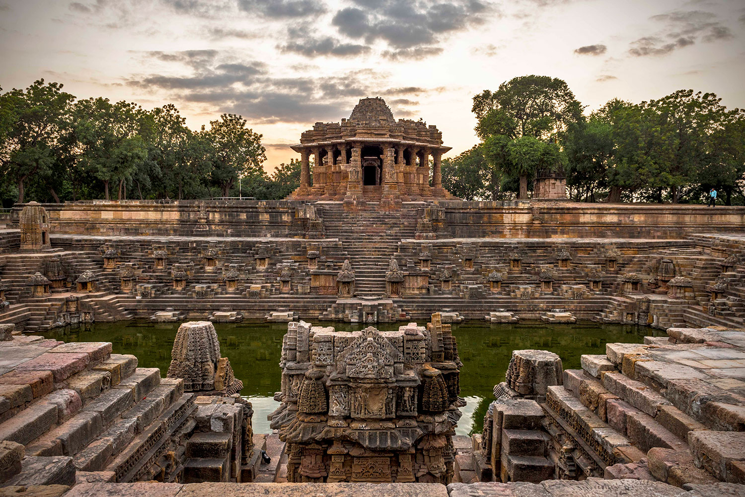
The Sun Temple is a Hindu temple dedicated to the solar deity Surya located at Modhera village of Mehsana district, Gujarat, India. It is situated on the bank of the river Pushpavati. It was built after 1026-27 CE during the reign of Bhima I of the Chaulukya dynasty. No worship is offered now and is protected monument maintained by Archaeological Survey of India. The temple complex has three components: Gudhamandapa, the shrine hall; Sabhamandapa, the assembly hall and Kunda, the reservoir. The halls have intricately carved exterior and pillars. The reservoir has steps to reach the bottom and numerous small shrines.
History
The shrine proper of the Sun Temple was built during the reign of Bhima I of Chaulukya dynasty. Earlier, during 1024–1025, Mahmud of Ghazni had invaded Bhima’s kingdom, and a force of around 20,000 soldiers had unsuccessfully tried to check his advance at Modhera. Historian A. K. Majumdar theorizes that the Sun Temple might have been built to commemorate this defense.[5] On a block in western wall of cella, there is an inscription “Vikram Samvat 1083” upside down carelessly incised in Devnagari script which correspond to 1026-1027 CE. No other date is found. As the inscription is upside down, it evidences the destruction and reconstruction of the cella. Due to the position of the inscription, it is not firmly considered as the date of construction. On the stylistic ground, it is known that the Kunda with its corner shrines was built earlier at the beginning of the 11th century. The inscription is rather considered as the date of destruction by Ghazni instead of the construction. Soon after Bhima had returned to the power. So the temple proper, the miniature and the niche shrines in the tank were built shortly after 1026 CE. The dancing hall was added much later in the third quarter of the 12th century along with the gateways, the porch of the temple proper and the doorframes of the temple and the cella during the reign of the Karna.The temple is built on 23.6° latitude (approximately near Tropic of Cancer). The place was later known as Sita ni Chauri and Ramkund locally.No worship is offered here now. The temple is the Monument of National Importance and is maintained by the Archeological Survey of India.
Architecture
The temple complex is built in Māru-Gurjara style (Chaulukya style). The temple complex has three axially aligned components; the shrine proper (garbhagriha) in a hall (gudhamandapa), the outer or assembly hall (sabhamandapa or rangamandapa) and a sacred reservoir (kunda).The Sabhamandapa is not in continuation with Gudhamandapa but is placed little away as a separate structure. Both are built on a paved platform. Their roofs have collapsed long ago leaving behind a few lower-most courses. Both roofs are 15′ 9″ in diameter but are constructed differently. The platform or plinth is inverted lotus-shaped.
Importance
The Sun Temple is a Hindu temple dedicated to the solar deity Surya located at Modhera village of Mehsana district, Gujarat, India. It is situated on the bank of the river Pushpavati.
Best Time To Visit
If we talk about the perfect month to visit this temple, the best time would be from October – March
12.Adalaj Stepwell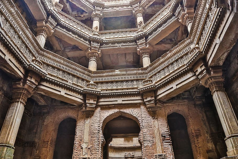
While in Gujarati and Marwari language, the stepwell is called a vav (leading down to the level of water), in other Hindi-speaking regions of North India, it is known as a baoli (also spelt, ‘bawdi’, ‘bawri’ and ‘bavadi’).Step wells like the one in Adalaj were once integral to the semi-arid regions of Gujarat, as they provded water for drinking, washing, and bathing. These wells were also venues for colorful festivals and sacred rituals.Stepwells, also called stepped ponds, built between the 5th and 19th centuries, are common in Western India; over 120 such wells are reported in the semi-arid region of Gujarat alone, of which the well at Adalaj is one of the most popular. Stepwells are also found in more arid regions of the Indian subcontinent, extending into Pakistan to collect rainwater during seasonal monsoons. While many such structures are utilitarian in construction, they sometimes include significant architectural embellishments, as in the Adalaj stepwell, which attracts many tourists. In the past, these stepwells were frequented by travelers and caravans as stopovers along trade routes.India’s first rock-cut stepwells are dated from 200-400 AD. Subsequently, the wells at Dhank (550-625) and construction of stepped ponds at Bhinmal (850-950) took place.The city of Mohenjo-daro has wells, which may be the predecessor of the step well; as many as 700 wells have been discovered in just one section of the city, leading scholars to believe that cylindrical brick lined wells were invented by the people of the Indus Valley civilization.Between third and second millennium BC, at the “Great Bath”, at the site of Mohenjodaro of the Harappan civilization, filling of water was achieved from a large well located in one of the rooms in front of the open courtyard of the building–complex.While early stepwells were made of stone, later step wells were made of mortar, stucco, rubble, and laminar stones. The well cylinder was the basic form used to deepen the wells. It is also inferred that the Stepwells in Gujarat have survived so long because of the builder’s knowledge of the soil conditions and the earthquake proneness of the region.The well size recommended, based on considerations of stability, was of four to thirteen hasta (‘hasta’ a Sanskrit word, which means “forearm” of size varying from 12–24 inches (300–610 mm)), A size of eight hasta was considered ideal, and a 13 hasta well was considered dangerous. However, the well thickness from top to bottom remained generally uniform. By the 11th century, the stepwell planning and design acquired architectural excellence and the Hindu Stepwells were standardized.
History
The Adalaj stepwell or ‘Vav’, as it is called in Gujarati, is intricately carved and is five stories deep. It was built in 1498. An inscription in Sanskrit establishes the history of the Adalaj stepwell found on a marble slab positioned in a recess on the first floor, from the eastern entry to the well. Its construction was started by Rana Veer Singh of the Vaghela dynasty of Dandai Desh. But he was killed in a war, whereafter the Muslim king Mahmud Begada of a neighboring state built it in Indo-Islamic architectural style, in 1499.
The Sanskrit inscription in the stepwell describes,
“Samvat 1555 (1498 AD), month of Magha, Mahmud Padshah being king.
“Salutation to Vinayaka (Ganesha) to whose race belonged King Mokala, chief of the country of Dandahi. From him was born Karna, . Mahipa , and Virsinh and Naisha were the sons of Mahipa. Virsinh’s queen, whose name is Rooda, has constructed this well.
“It is dedicated at this time – when the sun is in the north, the month is Magha, the bright half (Shukla Paksha), the 5th day, the day of the week, Wednesday, the lunar mansion – Uttara, Karana-Bava, the yoga – Siddhi.”
Then follows a glowing description of the well, after which the queen, or rather lady of the chief, is praised in a few verses; the expense is stated at 5,00,111 tankas or over five lakhs, and the whole ends with a repetition of the date as given above.[The cultural and architectural depiction in the deep wells at various levels are a tribute to the history of step wells, built initially by Hindus and subsequently ornamented and blended with Islamic architecture during the Muslim rule.
Architecture
Adalaj stepwell is five stories deep, built-in sandstone in the Solanki architectural style. A stepwell is built on an intricately carved large number of pillars with an octagonal plan at the top. Each floor is so spacious that the people can hold gatherings. The light and air can enter the octagonal well as it has an opening in the ceilings above the landing. It is dug so deep that one can access groundwater at that level, accounting for seasonal fluctuations in water level due to rainfall over the years. As the direct sunlight does not touch landings except at noon, the atmosphere inside the well is six degrees cooler than the outside. A unique feature of this stepwell is that from the first story level, three staircases lead to the bottom water level of the well.
A stepwell is called a Vav in the Gujarati language. The vav is a remarkable example of Indo-Islamic architecture and design. Mythological scenes carve the walls along with everyday scenes of women churning buttermilk, dancers accompanied by musicians, women adorning themselves, and a king sitting on a stool. The upper floors are carved by elephants which are 3 inches in size, each of different designs. The notable feature of the great monument is Navagraha at the end of the well. It is believed that Navagraha protects the historical site from evil spirits. It has three entrance stairs. A classical blend of Islamic floral, geometric designs, Hindu, and Jain icons and symbols make the stepwell remarkable.
The stepwell is open on all the days, and to enjoy the exciting play of light on the interiors of the stepwell. It is advisable to plan one’s visit so that the spectator is underground in the stepwell when the sun is up. The weather during October and March is quite pleasant in Ahmedabad and conducive for visiting the stepwell.
Importance
Adalaj ni vav (stepwells are called vavs in the Indian state of Gujarat) is a beautiful structure, descending five stories deep. It was built in 1499 to hold water, provide refuge to travelers and local people, and offer spiritual sustenance.
Best Time To Visit
October, November, December, January, February, March
13.Somnath Temple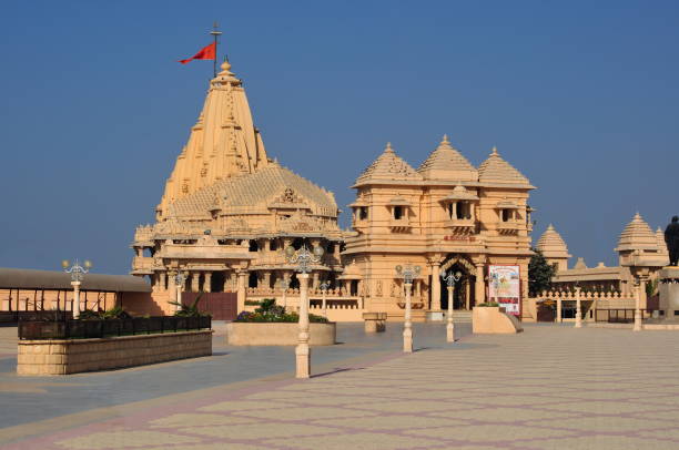
Somnath’s first temple is said to have existed 2000 years ago. Is. In 649 AD, King Maitre of Vallabhini built a second temple in place of the temple and renovated it. In 725, the old ruler of Sindh took his army and attacked the temple and destroyed the temple. Pratishtha King Nag Bhatt II constructed the temple for the third time in 815 using a red stone (sandstone) stone. In 1026, Mahmud Ghazni lent the precious jewels and property of Somnath temple. After looting, slaughtering innumerable pilgrims of the temple and burning the temple and destroying it. During 1026-1042 Solanki Raja Bhimdev built the fourth temple of Bhoj and Anhilwad Patan, Parmar King of Malwa.Somnath was destroyed when Delhi Sultanate occupied Gujarat in 1299. In 1394 it was destroyed again. In 1706, Mughal ruler Aurangzeb again demolished the temple.
History
Somnath is a magnificent temple situated in Sagar Kant of Saurashtra in Gujarat state. One of the 12 holy Jyotirlingas of Lord Shiva is in Jyotirlinga here in Somnath. Somnath is also mentioned in Rigveda. This temple of Somnath has been very attractive in front of many destructive foreign invaders who want to lure and convert to the temple glory. Whenever the temple has tried to destroy it, then it has been built again.
RECONSTRUCTION
India’s Iron Man and First Deputy Prime Minister Sardar Vallabhbhai Patel on November 13, 1947 promised to rebuild the temple. Today’s Somnath Temple is built on its original place in seventh place. When the temple was rebuilt on December 1, 1995, then the Indian President Dr. Shankar Dayal Sharma dedicated the temple to the country. In 1951, when India’s first President Dr. When Rajendra Prasad proposed to purify Jyotirling, he said, “This temple of Somnath is a symbol of victory over construction on destruction”. [Citation needed] The temple is built under Shri Somnath Trust And this trust is now monitoring the temple. Currently the chairman of the trust is former chief minister Keshubhai Patel and Sardar Patel was the first chairman of this trust.
The Kailash Mahameru Prasad Temple, built by Chalukya style, has a spectacular display of the art of Sompura artisans of Gujarat. This type of construction has not happened in the last 800 years. According to the inscription written in Sanskrit on the coast, only the sea exists between the temple and the southern part of the planet and there is no land.
Importance
One of the most celebrated pilgrimage sites, Somnath temple is located on the western coast of Gujarat. The temple holds much importance in the hearts of Lord Shiva devotees as it is believed to house one of the 12 Jyotirlinga in India, holy shrines which are considered to be where the Lord Shiva manifested.
Best Time To Visit
September to March are the best months to visit Somnath
14.Akshardham Temple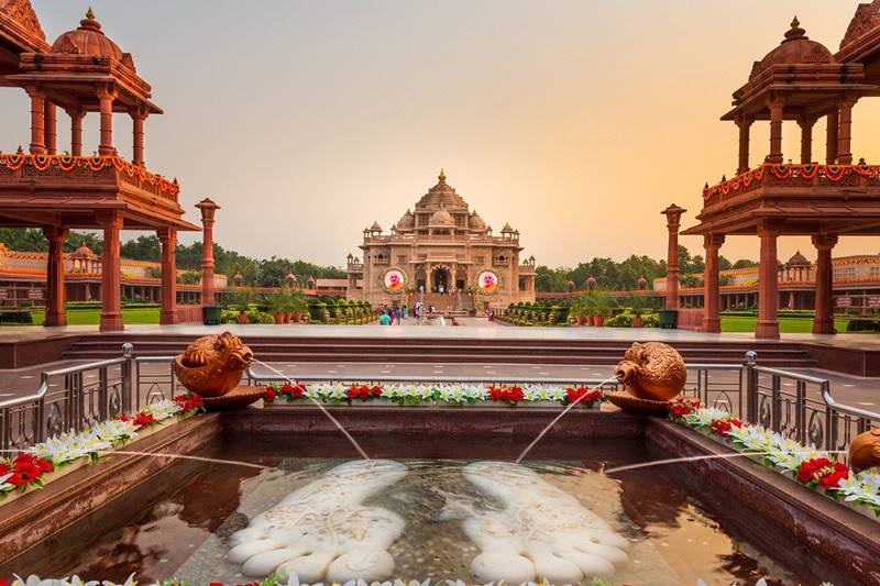
Akshardham is a majestic, intricately carved stone structure that stands amid sprawling gardens set in a 23-acre plot at Gandhinagar (Gandhinagar district). It is built in 6000 tonnes of pink sandstone and not a bit of steel has been used. The temple is 108 ft in height, 240 ft in length and 131 ft in width. A point worth noting is that this modern monument to Hinduism was built as per the injunctions of Vastu Shastra. The monument enshrining the seven-foot high, gold-leafed Murti (idol) of Lord Swaminarayan is the focal point of the complex.
The monument stands on 7 sculpted pillars, 210 single-piece stone beams, 57 window grills, M domes, eight ornate zarokhas, etc. The sanctum sanctorum contains the 1.2 tonne gold-plated idol of Lord Swaminarayan, the founder of the sect that bears his name, shown in a sitting posture with his right hand raised in abhay mudra. He is flanked by Swami Gunatitanand on his right and Swami Gopalanand Swami on his left. Both of them were his disciples. Swami Gunatitanand is called Swaminarayan’s Akshardham, the eternal abode. According to the Swaminarayan philosophy whenever Lord Swaminarayan incarnates on this planet he brings with him his Akshardham.
Gunatitanand Swami is also called Aksharbrahma and ranks second in the hierarchy of the Bochasanvasi Akshar Purushottam Sanstha which built the Akshardham monument. Inspiring episodes and incidents from the glorious history of Sanatan Dharma are presented in sound and light form for the benefit of the visitors. The show takes visitors through various facets of Hinduism. The wisdom of the Vedas, the epics, the Puranas are depicted on a crowded canvas by the exhibition. The visitor comes face to face with personages who have made this land what it is.It is a perfect mix of modernity and ancient values. Apart from Lord Rama going in search of his kidnapped wife, the visitor can see Shravan- the dutiful son, the Pandavas losing the game of dice in the Hastinapur palace, etc. Besides the visitors can also see Sabari’s long wait for Lord Rama and Draupadi’s humiliation in the Kauravasabha.
The Hall of Harmony projects world religions side by side. The monument is ringed by a parikrama containing 365 stone pillars. The temple also houses the Akshardham Center for Applied Research in Social Harmony (AARSH) which is a futuristic research center with a rich library, study stations, and archives. Access to the library is confined to enlisted scholars.
So far millions of people have visited the monument since its inception on November 2, 1992. They have been able to savour the story of Hinduism and to imbibe the message of universal peace and brotherhood.
Facts
The Akshardham Mandir is at the epicenter of the complex and is 108 feet high, 131 feet wide, and 240 feet long. It features 97 carved pillars, 17 domes, 8 balconies, 220 stone beams, and 264 sculpted figures. > The central chamber of the temple houses a 7 feet tall, gold-plated statue of Swaminarayan
Best Time To Visit
best place to visit is during winter from November to March when the weather is pleasantly cool.
15.Kutch Bustard Sanctuary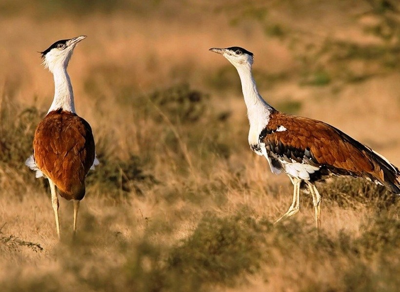
Kutch Bustard Sanctuary or Kachchh Great Indian Bustard Sanctuary,also known as Lala–Parjan Sanctuary, is located near Jakhau village in Taluka Abdasa, Gujarat, India. This sanctuary is one of the two great Indian bustard sanctuaries in Gujarat; the other one is in Jamnagar. It was declared as a sanctuary in July 1992, specifically for the conservation of the great Indian bustard, the heaviest flying bird belonging to the avian family of Otididae. However, the sanctuary presently legally covers a protected area of about 2 square kilometres (0.77 sq mi) of area (202.86 hectares (501.3 acres) of fenced land only and is the smallest sanctuary in the country. Several suggestions have been made to vastly increase the size of this sanctuary as it is a breeding ground of the endangered great Indian bustard. The reason is that its ecological zone is much larger on account of anthropogenic and cattle population pressure that are considered as a ‘biotic threat’ to this omnivorous species.
The main bird species of the sanctuary, the great Indian bustard, locally called “Ghorad,” is a Schedule I bird under the Indian Wildlife Protection Act of 1972. It is included in the Red Data list of the International Union for Conservation of Nature (IUCN).According to the studies conducted by the Bombay Natural History Society on three Indian bustard species – namely the great Indian bustard, the lesser florican and the Bengal florican – the estimated total population of the great Indian bustard in all 12 sanctuaries in the country is said to be only about 1,000, out of which only about 30 birds had last been counted within the sanctuary, second only to the Desert National Park in Rajasthan which reportedly had about 70–75 birds.Of the twenty three species of the bustards found in the world, the magnificent, tall, long-necked great Indian bustard (Ardeotis nigriceps) is the only one to have been recorded as endangered according to the 2009 IUCN Red List Category (as evaluated by Bird Life International – the official Red List Authority for birds for IUCN)This categorization is based on the fact that its population is on the decline as a result of hunting and continued agricultural development.
The sanctuary is bounded on the north by the Jakhau creeks, along the coast of Kutch. where large flocks of flamingos, herons, egrets, sandpipers and other birds can be seen.Located close to Nalia taluk, it encompasses the forest area of Jakhau and Budia villages.
The sanctuary comprises arid and semi-arid (dry) grasslands with scrubs containing scattered bushes and some cultivation. The bustard, which is mainly a terrestrial bird, has adapted to this habitat. As its natural habitat, it feeds on traditional agricultural produces such as bajra, juvar and other cereal crops and also on insects and reptiles.
The sanctuary lies in the ecological zone of the semi desert region. Hence, the climate is arid, rainfall is meagre and erratic, with an average annual precipitation of 384 millimetres (15.1 in). Evapotranspiration is high. Water sources totally dry up in summer but storage reservoirs meet the lean season water requirements.
Three distinct climatic seasons are noted; winter, summer and monsoon. The winter season is from middle of November to end of February and the average temperature recorded during the coldest month of January is 5 °C (41 °F). Summer season is from March to end of May when the temperature range is 40–45 °C (104–113 °F). Summer season sets in the middle of June or early July and covers the ecoregion and lasts till September.The ideal time to visit the sanctuary is from late monsoon to winter. The nearest large city Bhuj is 110 kilometres (68 mi) away. Bhuj has an airport which provides links with the rest of the country. Naliya is the nearest railway station, which is 20 kilometres (12 mi) away.
Importance
This sanctuary is one of the two great Indian bustard sanctuaries in Gujarat; the other one is in Jamnagar. It was declared as a sanctuary in July 1992, specifically for the conservation of the great Indian bustard, the heaviest flying bird belonging to the avian family of Otididae.
Best Time To Visit
October to February is the best time to visit this sanctuary. The most ideal way to enjoy this retreat is, take a walk around the nature’s cradle while befriending various species of the Bustard family. There is also a watchtower from there one can spot a flock of Indian Gazelle and wolves.
16.Polo Forest
Polo forest, also known as Vijaynagar forest, is a dry mixed deciduous forest near Abhapur village in Vijaynagar Taluka, Sabarkantha district, Gujarat, India. It is located at the foothills of the Aravalli range and on the banks of perennial Harnav river, spread over the area of 400 square kilometres (99,000 acres).
History
There was a town established by the Parihar kings of Idar around the Harnav river probably in the 10th century. It was conquered by the Rathores of Marwar in 15th century and came under Idar State. The town was located between two high hills, Kalaliyo and Mamrehchi, which blocks sunlight for the most days which probably resulted in the abandonment of the town.
The name Polo is derived from pol which literally means a gate in Marwari language.
Facts
The forest of Polo is spread in a vast area of 400 sq km, the temples here date back to 600 years from now. It is reckoned to be home to more than 450 species of medicinal plants, around 275 of birds, 30 of mammals, and 32 of reptiles. Also known as Polo Monument and Vijaynagar Forest, the jungle has four entry gates
Best Time to Visit
Polo Forest is one of the best tourist spots near Ahmedabad, Gandhinagar and Himmatnagar, especially in the Monsoon and Winter seasons (July to Feb). It is located north side of Gujarat near the Rajasthan border in the southmost mountain range of Aravalli. Forest is located near Vijaynagar
17.Statue Of Unity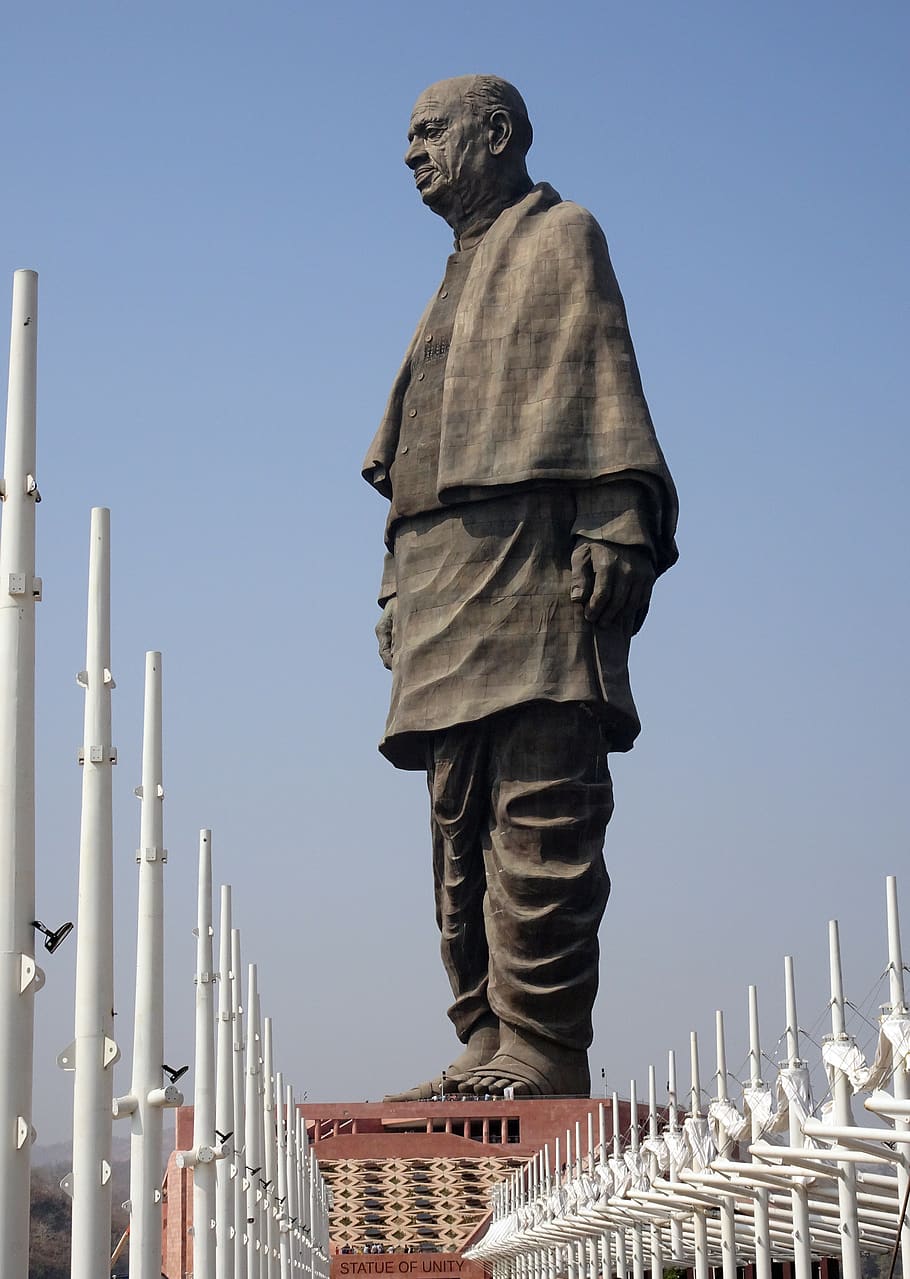
The Statue of Unity is a tribute to the Indian leader Sardar Vallabhbhai Patel, unveiled on 31 October 2018. This statue is a patriotic symbol of the legacy of a man who spent his life in the struggle for freedom. As a mark of respect the government built the statue of sardar vallabhbhai naming it a statue of unity.this statue is located at his birthplace in Gujarat. The statue is designed by Ram V. Sutar. The total amount for the project is US $430 million. The statue stands 182 metres high, making it one of the tallest monuments in the world, second to the St. Louis Arch.
The Statue of Unity is at Sadhu Bet Island. A 12 km square lake will create the atmosphere of equality and diversity. A special trust called as “Sardar Vallabhbhai Patel Rashtriya Ekta Trust” has been created for to manage the place. The statue is made with steel frame and reinforced concrete. For durability, the statue has been given bronze plating. The statue has a 153 m high viewing deck able to hold 200 visitors. It has a panoramic view of the Sardar Sarovar Dam.
It has been designed to withstand winds of velocity of 60 metres/second, and is also claimed to be earthquake resistant. A total of 22,500 tons of cement forms the core structure of this monument. The iron used in the construction was collected from old farm equipment throughout India. A team of 700 Indian workers worked on the sementing and casting.
Facts
1.Highest Statue in the World
2.Huge Number of engineers and workers worked to build the Statue of Unity
3.Cost to build the Statue
4.Materials Used In Making of The Statue Of Unity
5.Design of the Statue
6.Beautiful Location of the Statue
7.Bronze Cladding of the Statue
8.About the Height of the Statue
9.India’s Farmers Contribution in making of the Statue
10.Amazing Toughness of the Statue
11.Aging of the Statue
12.The High Speed Lift Inside Statue Of Unity
13.Things inside the Statue Of Unity
14.The Amazing Night Show
Importance
The statue has been built as an ode to the Iron Man of India, Sardar Vallabhbhai Patel, the first home minister of independent India. He was responsible for uniting all 562 princely states of the country to build the Republic of India.
Best Time To Visit
The best time to visit the Statue of Unity is in the cooler months of October to February, though the site is open all through the year. The Statue of Unity opens at 8:00 AM and closes at 6:00 PM from Tuesday to Sunday.
18.Champaner Archaeological Park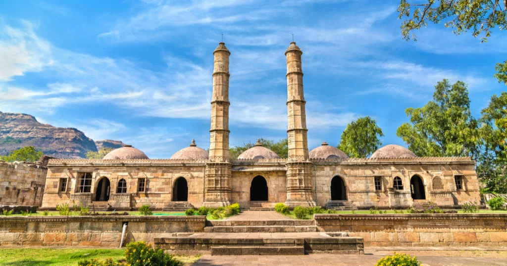
A UNESCO Heritage site, Champaner and Pavagadh are often clubbed together as one of the most engaging historical attractions of Gujarat. Pavagadh stands on top of the hill that looks over the sprawl of monuments at the base in Champaner. The duo makes a rich heritage site dotted with forts, mosques, monuments, tombs, arches, temples, step-wells and fortresses from 8th to 14th century. Today, throngs of pilgrims ascend Pavagadh to worship at the important Kalikamata Temple, dedicated to the goddess Kali, who sits atop the summit. Champaner is the only unchanged Islamic-Mughal city over the centuries, offering an authentic flavour of architecture of the era. Juxtaposed to this is the Kalika Mata Temple on the Pavagadh Hill, where thousands congregate during Navratris.
At the heart of Champaner, is the Citadel, whose most impressive features are its 16th-century monumental mosques (no longer used for worship), with their beautiful blending of Islamic and Hindu architecture. The huge Jami Masjid, just outside the Citadel’s east gate, boasts of a wonderful carved entrance porch that leads into a lovely courtyard surrounded by a pillared corridor. The prayer hall has two tall central minarets, further superb stone carving, multiple domes, finely latticed windows and seven mihrabs (prayer niches) along the back wall.
Other beautiful mosques include the Saher ki Masjid, behind the ticket office inside the Citadel, which was probably the private royal mosque, and the Kevda Masjid, 300m north of the Citadel and about 600m west of the Jami Masjid. Here you can climb narrow stairs to the roof, and higher up the minarets, to spot other mosques even further out into the countryside – Nagina Masjid, 500m north, with no minarets but exquisite geometric carving, particularly on the tomb next to it, and Lila Gumbaj ki Masjid, 800m east, on a high platform and with a fluted central dome. The twin minarets resembling factory chimneys, about 1 km west, adorn the Brick Minar ki Masjid, a rare brick tomb.
History
Pavagadh became the capital of the Chauhan Rajputs around 1300, but in 1484 was taken by the Gujarat Sultan Mahmud Begada, after a 20-month siege; the Rajputs committed jauhar (ritual mass suicide) in the face of defeat. Following his capture of Pavagadh, Sultan Mahmud Begada turned Champaner, at the base of the hill, into a splendid new capital. But its glory was brief: when it was captured by Mughal emperor Humayun in 1535, the Gujarati capital reverted to Ahmedabad, and Champaner fell into ruin.
Facts
The Turkish rulers of Gujarat conquered the hill-fortress in 1484. With Sultan Mehmud Begda’s decision to make this his capital, the most important historic phase of this site began. The settlement of Champaner at the foot of the hill was rebuilt and remained the capital of Gujarat until 1536, when it was abandoned.
Importance
The Kalika Mata Temple, located on top of the 800 metres (2,600 ft) high Pavagadh Hill, is an important Hindu shrine in the region, attracting large numbers of pilgrims throughout the year.
Best Time To Visit
NOV-FEB. Peak Season.
JUL-OCT. Moderate Season.
MAR-JUN. Off-season.
19.Pols Of Ahmedabad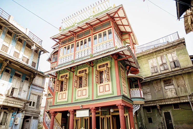
A pol (pronunciation (help·info), pronounced as pole, Gujarati: પોળ) in India is a housing cluster which comprises many families of a particular group, linked by caste, profession, or religion. Pols are typical of urban centres in Gujarat especially of Old Ahmedabad.
The word pol is derived from the Sanskrit word pratoli meaning entrance to an enclosed area.
Architecture and culture
Pols were originally made as a protection measure when communal riots necessitated greater security probably dating from 1738 during Mughal-Maratha rule (1738–1753) in Ahmedabad. A typical pol would have only one or two entrances and also some secret entrances known only to people residing in a pol. Some pols contain old beautiful houses with internal courts having intricate wooden carved facades with columns and fresco work done around court walls or ceilings. Pol architecture is an interesting evolution in urban living space.[original research?
Each pol was protected by a gateway closed at night as a safeguard against thieves. Inside is one main street, with crooked lanes branching on either side. Most vary in size from five or ten to fifty or sixty houses. One of them, the Mandvi pol in the Jamalpur area of Ahmedabad, is much larger than the rest and includes several smaller pols, with an area of about fifty acres and a population of thousands. Pols are almost entirely inhabited by Hindus, in some cases by a settlement of families belonging to one caste, and in others by families of several of the higher castes, Brahmins, Vanias, Suthars, and Kanbis.
Most pols have been established and with a gateway, some provided at the expense of the Pol’s leading man whose name the pol in many cases bears, and whose family holds a position of respect as the heads of the pol. Each pol had generally its own watchman and its own sanitary arrangements. The affairs of the pol were managed by a group of people. The house property in the pol is to some extent held in common. Formerly no man could sell or mortgage a house to an outsider without first offering it to the people of the pol. Though this rule has not been kept latterly, residents of a pol sold their houses to people of the same caste. When a house is mortgaged or sold, the people of the pol had a right to claim from one-half to two per cent of the money received. At weddings and on other great family occasions, each householder is expected to feast the whole pol, and in some cases all the men of the pol, though not of the same caste, are expected to attend any funeral that may take place. If the pol rules are slighted, the offender is fined and, in former times, till he paid, he was not allowed to light a lamp in his house or to give a feast. The money gathered from gifts, fines, and the percentage on house property sales, formed a common fund managed by the leaders, seths, of the pol. This was spent on repairs to the pol gate, the pol privies, or the pol well. The polia or gate-keeper is not paid out of the fund. He earns his living by begging from the people of the pol and works as a labourer for them.
The chief feature of these pols is that each has a separate entrance protected by a gateway, pol, with a picket house on the top of it. Inside of the gateway the houses of the group form one or more streets, the ends either blocked by a dead wall, or, through a small door, bari, opening into another pol. Inside the pols the roads are rough, narrow, and winding, fit in many cases only for foot passengers. Most of the houses are first class, the walls massive and the timber strong. Some of them, especially those about more than hundred years old, are ornamented with much rich and finely cut wood-work. From their fondness for this part of the town and the want of open sites, the families as they grew larger, added story on story to the old houses, the upper stories often jutting out so far that, when two opposite houses were enlarged, their eaves almost met across the roadway. Inside of most two or more storied houses is a yard, and under the yard a covered reservoir with supplies of rain water for drinking. Part of the courtyard is sometimes raised into a terrace and used as a lounge or for drying grain, pulse, and clothes. In these houses valuables are, if unwieldy, stowed away in secret under-ground cellars with most carefully hid entrances. Some of these cellars have air shafts run through the walls, so that they may be used as retreats for men in hiding. The jewellery safe is usually a hole in the house wall or in one of the main beams, hidden so cunningly that no stranger can find it out, and its secret so jealously guarded, that it is known only to the head of the house, his wife, and one or two of his most trusted children. The people of these pols form, to some extent, separate communities, each with arrangements for managing its common affairs.
Pols
The old city of Ahmedabad located on the Eastern banks of the Sabarmati river is made up of around 360 pols within a fortified compound. The earliest ‘Pol’ to be incorporated was aptly christened ‘Mahurat Pol’ and was built adjacent to Manek Chowk
Facts
Pols were originally made as a protection measure when communal riots necessitated greater security probably dating from 1738 during Mughal-Maratha rule (1738–1753) in Ahmedabad. A typical pol would have only one or two entrances and also some secret entrances known only to people residing in a pol.
Best Time To Visit
Better to visit in winter (November to February) & do not miss delicious breakfast at Magaldas Haveli & authentic Guajarati Lunch or Dinner at House of Mangaldas. This walk covers old city area. During walk tourist can enjoy leaving culture of old city by passing through different pols.
20.Sabarmati Ashram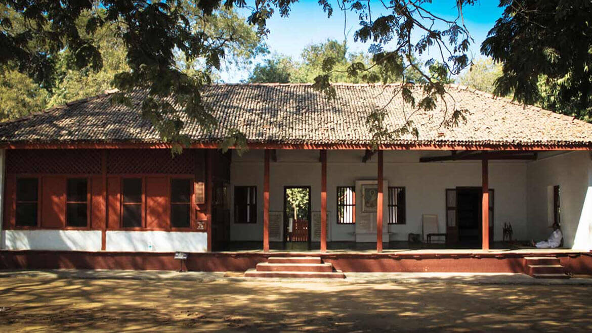
Sabarmati Ashram (also known as Gandhi Ashram) is located in the Sabarmati suburb of Ahmedabad, Gujarat, adjoining the Ashram Road, on the banks of the River Sabarmati, 4 miles (6.4 km) from the town hall. This was one of the many residences of Mahatma Gandhi who lived at Sabarmati (Gujarat) and Sevagram (Wardha, Maharashtra) when he was not travelling across India or in prison. He lived in Sabarmati or Wardha for a total of twelve years with his wife Kasturba Gandhi and followers, including Vinoba Bhave. The Bhagavad Gita was recited here daily as part of the Ashram schedule.
It was from here that Gandhi led the Dandi march also known as the Salt Satyagraha on 12 March 1930. In recognition of the significant influence that this march had on the Indian independence movement, the Indian government has established the ashram as a national monument.
History
Gandhiji’s India ashram was originally established at the Kocharab Bungalow of Jivanlal Desai, a barrister and friend of Gandhi, on 25 May 1915. At that time the ashram was called the Satyagraha Ashram. But Gandhi wanted to carry out various activities such as farming and animal husbandry, in addition to other pursuits which called for the need of a much larger area of usable land. So two years later, on 17 June 1917, the ashram was relocated to an area of thirty-six acres on the banks of the river Sabarmati, and it came to be known as the Sabarmati Ashram.
It is believed that this is one of the ancient ashram sites of Dadhichi Rishi who had donated his bones for a righteous war. His main ashram lies in Naimisharanya, near Lucknow, Uttar Pradesh. The Sabarmati ashram is sited between a prison and a crematorium, and Gandhi believed that a satyagrahi has invariably to go to either place. Mohandas Gandhi said, “This is the right place for our activities to carry on the search for truth and develop fearlessness, for on one side are the iron bolts of the foreigners, and on the other the thunderbolts of Mother Nature.”
While at the ashram, Gandhi formed a tertiary school that focused on manual labour, agriculture and literacy, in order to advance his efforts for the nation’s self-sufficiency. It was also from here that on 12 March 1930, Gandhi marched to Dandi, 241 miles from the ashram, with 78 companions in protest at the British Salt Law, which increased the taxes on Indian salt in an effort to promote sales of British salt in India. It was this march and the subsequent illegal production of salt (Gandhi boiled up some salty mud in seawater) that spurred hundreds of thousands across India to join in the illegal production, buying or selling of salt. This mass act of civil disobedience in turn led to the imprisoning of some 60,000 by the British Raj over the following three weeks. Subsequently, the government seized the ashram. Gandhi later asked the Government to give it back but they were unwilling. By 22 July 1933 he had already decided to disband the ashram, which had become a deserted place after the detention of so many. Then local citizens decided to preserve it. On 12 March 1930 Gandhi had vowed that he would not return to the ashram until India had gained independence and Gandhi did not come back to Sabarmati ashram. Gandhi was assassinated on 30 January 1948
Best Time To Visit
October to March.
21.Wild Ass Sanctuary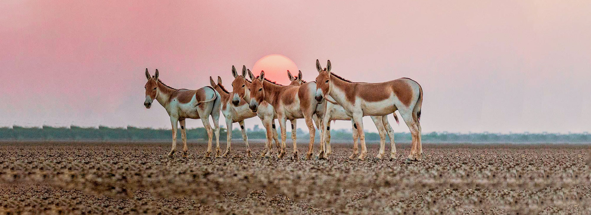
Located in an area called Little Run of Kutch, the Wild Ass Sanctuary in Kutch is the only home to wild ass in India. The sanctuary was set up in 1973 with a purpose to protect the endangered Indian wild ass. Sprawling over an area of 5000 square kilometers of the Little Rann and covering a minor portion of the cities like Sundernagar, Rajkot, Patan, Banaskantha and Kutch district, the wild ass sanctuary is the largest wildlife sanctuary in Gujarat. Indian Wild Ass (Equus hemionus khur), commonly known as the ghudkhar, still exists in this sanctuary. Akin to the Tibetan kiang, the ghudkhar are distinguished by a dark stripe along its back. Known for its speed, the wild ass lives in herds led by stallions and survived by migrating between the grassy ‘bets’ through the season, in search of food. There are around 3000 wild asses in the sanctuary and can be best seen in and around October and November.
Wild Ass Sanctuary Kutch
Other than the wild ass, the sanctuary is home to 32 other type of mammals including chinkara(Indian gazelle), two types of Desert Fox (Indian and White-footed), Jackals, Caracals, Nilgais (the largest antelope of Asia), Indian Wolves, Blackbucks, and Striped Hyenas. Every year, the Wild Ass Sanctuary attracts 75000 birds, including some migratory birds as well. The sanctuary is also refugee to some migratory birds like Sandgrouses, Desert Wheatears, Ten Species of Lark, the White-Browed Bulbul, Indian Coursers, Stoneplovers, Shrikes, Ducks, Geese, Ibis, Spoonbills, Godwits, Stints, Sandpipers, Shanks, Moorhens, Saras Cranes, both Indian Flamingoes, and Pelicans. The sanctuary also houses 93 species of invertebrates, including species like crustaceans, insects, molluscs, spiders, annelids and zooplanktons.
Also, the sanctuary is home to a sizeable population of Rabari and Bharwad tribes. To experience the best of the wildlife sanctuary, one should go for a jeep safari tour. It is to be noted that the Wild Ass Sanctuary has one of the largest salt pans in India. Tourists who are visiting the sanctuary can book their stay in the resorts and hotels nearby the sanctuary. Day safari from Dhrandadhra, Zainabad and Dasada are provided by the resort. Wild Ass Sanctuary is no less than an empyrean for the tourists, needless to say- of all kinds!
Best Time To Visit
October to June
22.Sidhpur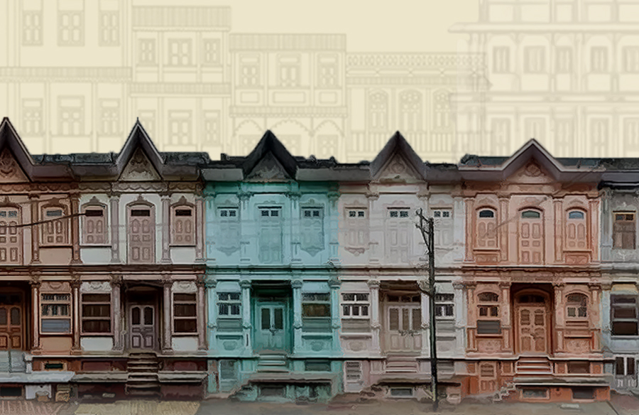
With a powerful place in history and mythology, Sidhpur is a sleepy little town in North Gujarat. Making Sidhpur a sacred pilgrimage among Hindu devotees honoring their maternal ancestors, it was here on the banks of the Saraswati River that the great warrior Parasurama performed the last rites of his mother. Sidhpur has its special place in collective Hindu consciousness and it is often deemed as the “Kashi or Varanasi of the West.”
Named after the lauded king Siddhraj Jaisingh of the Solanki Dynasty, the town rose to prominence during his rule and became the capital of the state. Today, Sidhpur’s crowning glory is the European-styled architecture that was built more than 100 years ago in the Muslim neighborhood of Najampura.
History
Referring to the 10th century Solanki ruler Siddhraj Jaisingh, Sidhpur literally means “Siddhraj’s town.” It is said that the town was flourishing at its peak under his rule. Rudra Mahalaya, a temple dedicated to Shiva, was built by Siddhraj Jaisingh, which is now in ruins. On his way to Somnath, Mohammed Ghori destroyed Sidhpur in the 12th century and the Solanki dynasty ended with it.
Architecture
The Dawoodi Bohras, a trading community, flourished in Sidhpur from the 1820s to the 1930s. They built monumental mansions, made of wood, with stuccoed facades, ornate pilasters, trellised balconies and gabled roofs which have become identifying features of the architecture of this town. The façades of these houses are in a hue of pastel colours – pink, lilac, lime green, peach, lemon, beige and the like and every house façade has an intricate monogram with the initials of the owners (in Latin text).Sebastian Cortés has captured detailed photographs of these architectural marvels which were displayed at an exhibition in Mumbai, India. On Sidhpur, Cortés said, “I would feel safe to say that it incorporates elements that span from neoclassical European, including art nouveau, and touching Indian Gothic. But if you begin to look closely, you can find other influences; this variety makes Sidhpur a marvel for the eye
Places To Visit In Sidhpur
1.Patan Patola Heritage Museum
2.Panchasara Parshwanath Jain Derasar
3.Modhera Sun Temple
4.Rani Ki Vav
5.Rudra Mahalay
Best Time To Visit
The weather conditions in Sidhpur remain pleasant from January to May and October to December. As a traveler, you can consider these time periods to be the best time to visit Sidhpur to enjoy the breathtaking adventure sports and outdoor activities.
23.Amba ji Temple
Ambaji History
Ambaji is one of the 51 ancient Shakti Peetha Tirth in India. There are 12 main Shakti Pith Tirth, significant places of pilgrimage for the worship of Shakti, namely, Ma Bhagwati Mahakali Maha Shakti at Ujjain, Ma Kamakshi at Kanchipuram, Mata Bramaramba at Srisailam, Shri Kumarika at Kanyakumari, Mataji Ambaji at AnartGujarat, Mata Mahalaxmidevi at Kolhapur, Devi Lalita at Prayag, Vindhya Vasini at Vindhya, Vishalakshi at Varanasi, Mangalavati at Gaya and Sundari at Bangal & Guhyeshwari Temple in Nepal.
There is no idol or picture in the temple but a simple cave like Gokh in the inner wall, in which A Gold Plated Holy Shakti Visa Shree Yantra having kurma back convex shape and 51 Bij letters therein, connected with that of the original Yantras of Nepal and Ujjain Shakti Piths, is also ritually installed in such a way it can be visible for devotion, but never photographed in past nor can be so done in future. The worship of this Visa Shree Yantra is done only after tying a bandage on the eyes.
Gabbar hill is situated on the border of Gujarat and Rajasthan, near the flow of the origin of the famous Vedic virgin river Sarasvati, on the hills of Arasur in forest, towards south-west side to ancient hills of Arvalli, at the altitude of about 480 meters, at about 1,600 feet (490 m) high from sea level, having at 8.33 km2 (3.22 sq mi) area as a whole, and it is in fact One of the 51 famous Ancient Shakti Peeths and it is place of where the heart of the deadDevi Sati fell at the top of hill of Gabbar as per the legend narrated in the “Tantra Chudamani”. The Mountain or Hill of Gabbar has also a small temple fortified from the western side and there are 999 steps to go up to the mountain and reach this holy temple at the top of Gabbar Hill. A Holy Lamp is constantly burning on this hill temple facing exactly in front of Visa Shree Yantra of Nij Mandir of Mata Shri Arasuri Ambica. There are many more beautiful sightseeing Places on Gabbar together with a sunset point, Cave and Swings of Mataji and Trips through a ropeway. As per recent study Ambaji Temple was constructed by the Suriyavans Emperor Arun Sen, the ruler of Vallabhi in 4th Century A.D.
Temple Timings:-Ambaji temple is open for darshan all seven days of the week. The visiting hours are – 07:00 AM to 11:30 AM, 12:30 PM to 04:30 PM and 06:30 PM to 09:00 PM.
24.Marine National Park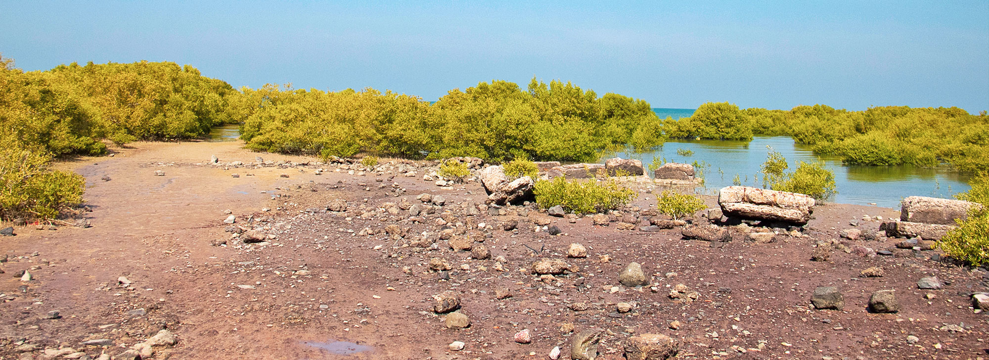
Marine National Park, Gulf of Kachchh situated on the southern shore of Gulf of Kachchh in Jamnagar District. It is the first Marine National Park in the country declared in the year 1980. However, the first record of scientific study of marine biodiversity of this Gulf region dates back to 1909. The Maharaja SayajiraoGaekwad of erstwhile Baroda State commissioned Mr. James Hornell, a well-known Marine Biologist from Sri Lanka to study marine life of Okhamandal coast. It was astonishing for Mr. Hornell and in his words “I had never seen before such a rich marine biota in so confined a place”. Subsequent research studies revealed many obscure facets of this rich marine biodiversity and its ecology. A well-organized fishery of pearl oysters and windowpane oysters was carried out by the Princely Navanagar State in this region. The ecological significance of this coastal ecosystem was discussed in the seminar for conservation of forests and wild animals held at SasanGir in 1980. The seminar was chaired by Hon’ble Prime Minister of India, Smt. Indira Gandhi. It was decided in the seminar to protect and develop marine biodiversity in this area and with this background, Government of Gujarat declared 457.92 sq.km area as Marine Sanctuary vide notification No. AKH-140.8o-WlP-10. 19,109-107483-P2 dated 12-8-1980 and AKH-139(1)182- WLP-108-126827-V2 dated 20-7-1982. It was a historical step towards conservation of marine biodiversity and resources in the country as with this, India’s first Marine Protected Area came into existence. Later, an additional of 162.89 sq .km area was declared as Marine National Park vide notification No. AKH-138(2)-182-WlP-108-126827-V2 dated 20-7-1982. At present, the total area under Jamnagar Circle is 944.0 sq.km. which include MNP & S, Khijadiya Bird Sanctuary, Gaga Wildlife Sanctuary, Reserve Forests, Protected Forests and Section – 4 area
The Marine National Park and Sanctuary (MNP & S) is situated along the southern coast of Gulf of Kachchh in DevbhumiDwarak, Jamnagar and Morbi districts between 20° 15′ N to 23° 40′ N latitudes and 68°20′ to 70°40′ E longitudes. There are 42 islands, encompasses a variety of habitats viz., coral reefs, mangrove forests, sandy beaches, mudflats, creeks, rocky shore, seagrass beds, wide intertidal region etc. The MNP also known for its species diversity with 49 species of hard corals, 23 species of soft corals, 70 species of sponges, more than 200 species of fishes, 27 species of prawns, 30 species of crabs, 199 species of mollusk, 16 species of echinoderms, 172 species of birds, 3 species of sea mammals, 6 species of mangroves, 3 species of sea turtle, 108 species of brown, green and red algae, etc. These habitats caters to the needs of thousands of flora and fauna and provides them suitable shelter. As per the International Union Conservation of Nature (IUCN), the Marine National Park and Sanctuary is categorized under Category I of Marine Protected Areas with 130 MPAs functioning in the country of which most are located in Andaman and Nicobar Islands and on the eastern coast of the mainland of the country.
Best Time To Visit
October to June
25.Velavadar National Park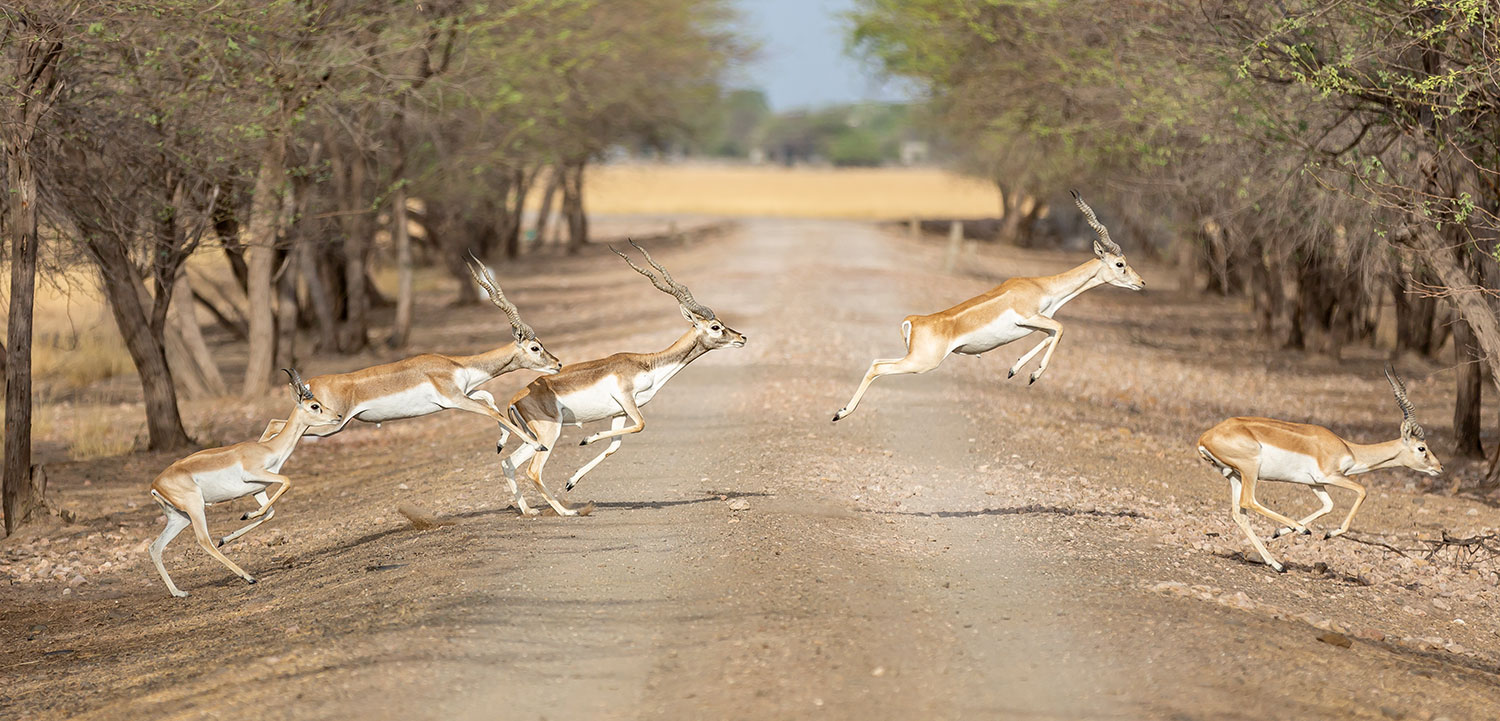
his beautiful, 34-sq-km park that is an hour’s drive north of Bhavnagar, encompasses large areas of pale, custard-coloured grassland stretching between two seasonal rivers and is famous for its blackbucks – beautiful, fast antelope that sport elegant spiraling horns as long as 65cm in mature males. Some 1800 inhabit the park, alongside blue bulls (India’s largest antelope) and birds such as wintering harriers from Siberia (about 2000 of them most years). There are over 120 species of birds that can be found in the park and around. If you’re lucky, you may even spot wolves! The best time to visit the sanctuary is early in the morning when chances of seeing the wolves are a lot more. In the day, the blackbucks are easy to spot but the wolves are elusive. The pale gold grassland is dotted with clusters of blackbucks. They move around in gendered groups – the males together, and the females and fawns in their own groups. It is good that hiring a guide is mandatory as anecdotes about the animals and life in the village are always fun to know more about.
History
The sanctuary was established in July 1976, as an initial protected area of about 18 sq km. In 1980, another 16 sq km were added to increase the total area to 34 sq km. Even though this is one of the smallest national parks of the country, it packs in a robust amount of species for the wildlife lover.
Best Time To Visit
The best time to visit the sanctuary is early in the morning when chances of seeing the wolves are a lot more.
26.Idar Hill Fort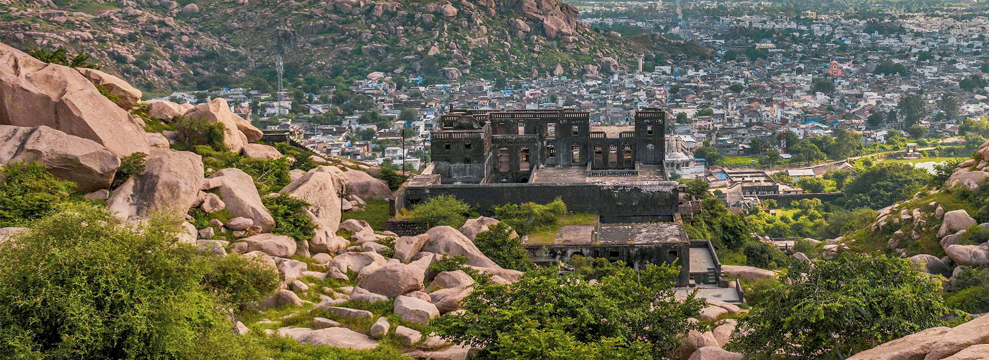
Idar Gadh is overseeing the Aravali Range and offers a great view of the valley. Gadh has evidently included hill fort, for this reason, included from different attacks
History
The Maharaja Daulat Singh built this palace fort in the 20th century.
There are a few locations of spiritual vacationer hobbies along the way, just like the Zarana Mahadev Temple in a cave. The temple withinside the cave is a Shivling, which has a perpetual delivery of water, and therefore, the call of the temple is Zarna Mahadev. Zarana in Hindi way a waterfall. The other thriller approximately this citadel press is the beginning of the water delivery to the Zarna Mahadev.
Architecture
When you visit the Idar Gadh or Idar Fort, you in the end see a shape of pink granite, and that makes it remarkably beautiful.
Facts
38 km from Vijaynagar, this former princely state lies hugged by the Aravali mountain range, which gave it protection from various attacks in its history. In addition to some of the larger temples, look out for the signs of worship of smaller idols scattered up the hills.
Importance
The entire big fort is built on top of hills, 160 metres high and it was mainly built for the purpose of defence against invaders. Idar is an ancient fort, known as ‘Ilva Durga’ and finds mentioned in Mahabharat and in the travelogue of the Rathore Rajputs in the Mahi Kantha agency at the time of British Raj.
Best Time To Visit
Trekking to the fort is good try to find good day of monsoon